Blackwater Bay
la bahía del Aguasnegras
Blackwater Bay is the great inlet of the Narrow Sea on which King's Landing stands, at the mouth of the Blackwater Rush.
Its waters, watched over by the royal fleet and guarded by Dragonstone at the mouth of the Gullet, were the setting for one of the most remembered naval battles in the Seven Kingdoms.
Chapter 1
A dangerous bay
Books and show
The bay opens on the eastern coast of Westeros, a natural gateway from the Narrow Sea into the heart of the Seven Kingdoms. The Gullet marks its outer edge, a narrow passage between Sharp Point and Massey's Hook, with Dragonstone watching over the approach.
Within the bay rise headlands and shoals that sailors call the King's Pescadilla's Harpoons: for every rock that breaks the surface, a dozen more lie hidden below it, and crossing that stretch blind means risking the ship. Ships of the royal fleet of the Iron Throne patrol these waters to keep them clear of piracy.
Besides King's Landing, the bay holds other ports: Duskendale, which takes the overflow when the capital's traffic runs too heavy, and Driftmark, the largest island in the bay and seat of House Velaryon.
Chapter 2
The chain that closed the river
299 ACBooks and show
 Stannis Baratheon
 Tyrion Lannister
In 299 the mouth of the Blackwater Rush, where the river meets the bay, was the setting for the battle between the fleet of Stannis Baratheon and the royal navy of Joffrey Baratheon.
Tyrion Lannister, then acting Hand of the King, had ordered a great chain built to seal the river off from the bay. With Stannis's fleet trapped upriver, wildfire caught and destroyed much of it.
The physical world
Los marineros los denominan los Arpones del Rey Pescadilla; por cada islote que se asoma por encima de la superficie, una docena se encuentra bajo el agua, haciendo la navegación peligrosa en ese punto.
What it is like · Tormenta de Espadas, Capítulo 5, Davos.
Gallery
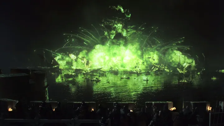
Blackwater BayWildfire explosion.jpg · gameofthrones.fandom.com · this wiki publishes under CC-BY-SA

What we are not sure about
PositionWe worked it out
The position was inferred from the label on the base map rather than from a symbol of its own: it marks the area, not the point.